


China LJ-CAUS20 Integrated Anti-UAV Platform - Leading Suppliers and Factory Solutions for Drone Detection and Control
Introduction
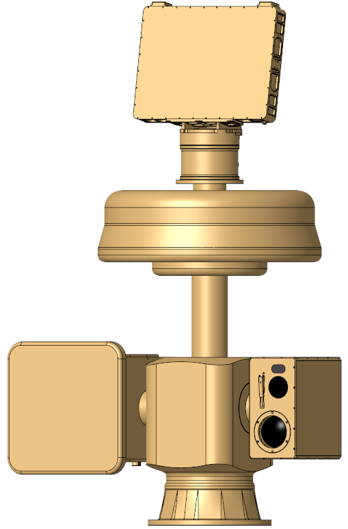
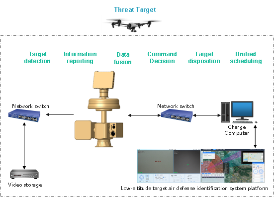
The LJ-CAUS20 anti-UAV integrated platform consists of a spectrum detection system, a radar detection system, an optoelectronic tracking and suppression jamming system and a low-altitude target prevention and control identification system platform.
The platform is independently developed and produced by SUNPOO. Through the double-layer servo turntable design, the detection and disposal modules are highly integrated, and the low-altitude target prevention and control identification system platform is uniformly dispatched, giving full play to the detection advantages of each equipment and ensuring that each equipment works independently while achieving more efficient linkage and precise strike. The modular design of the system allows the detection and disposal modules to be flexibly matched according to customer needs, and the optical configuration to be flexibly selected to meet the needs of detection, identification, and countermeasures under all-weather and different usage scenarios.
Key Indicators
| Name | The LJ-CAUS20 anti-UAV integrated platform | |
| Protective airspace range |
Typical target: DJI Elf 4 Spectrum detection distance: ≥ 5 km (spherical); Radar detection range: ≥2. 5km (sector-shaped stereo); Photoelectric detection distance: ≥ 2. 5km, tracking ≥ 2km (fan-shaped stereo); Interference distance: ≥ 2km (spherical); |
|
| Spectrum detection |
1. Detection distance: ≥ 5 km; 2. Detection frequency: 300MHz ~ 6GHz full frequency band; 3. Direction finding frequency: 800MHz, 900MHz, 1.1 GHz, 1.2 GHz, 1.4 GHz, 1.5 GHz, 2.4, 3.3 GHz, 5.2 GHz, 5.8 GHz; 4. Direction finding accuracy: better than 15 ° (RMS); 5. Effective airspace coverage: 0 ° ~ 360 °; 6. Operating temperature: -40 ℃ ~ + 65 ℃; 7. Protection level: IP66. |
|
| Radar detection |
1. Detection system: one-dimensional phased array radar, azimuth machine scanning, pitch electronic scanning; 2. Detection distance: ≥ 1.5 km (typical target: DJI Elf 4, RCS: 0.01 m²); 3. Measurement accuracy: 4. Scanning range: 5. Data refresh rate: ≤ 2 s; 6. Multi-target processing capacity: ≥ 100 batches; 7. Detectable target flight speed range: 1m/s ~ 100m/s; 8. Short-range detection blind area: ≤ 50 m; 9. Protection level: ≥ IP65; 10. Weight: ≤ 25 kg; 11. Size: ≤ 550 mm * 380 mm * 220 mm; 12. Communication interface: RJ45; 13. Power supply: DC 24V (adapted to ~ 220V ± 10%, 50Hz ± 5% through external power supply); Overall machine power consumption: 200W; |
|
| Suppress interference |
1. Suppression distance: ≥ 2km (target transmission power ≤ 20 dbm); 2. Suppression frequency: 433MHz, 800MHz, 900MHz, 1.1 GHz, 1.2 GHz, 1.4 GHz, 1.5 GHz, 2.4, 3.3 GHz, 5.2 GHz, 5.8 GHz; 3. Jamming flat panel antenna: 4. Interference with the chassis: |
|
| Photoelectric tracking | Infrared thermography |
1. Resolution: ≥ 640 * 512; 2. Lens: focal length 20 ~ 100mm; 3. Lens control: electric zoom, manual/auto focus; 4. Image enhancement: SDE digital image detail enhancement technology; |
| High definition visible light |
1. Resolution: ≥ 1920 * 1080, focal length 7-330mm; 2. Focal length: 7 ~ 330mm high-definition electric zoom lens; 3. Fog penetration: supports photoelectric/electronic double fog penetration; |
|
| Tracking distance |
1. Target tracking distance: ≥ 2.5 km during the day; Recognition distance ≥ 2km (target size equivalent to DJI Elf 4); 2. Target tracking distance: ≥ 1000m at night; Recognition distance ≥ 800m (target size equivalent to DJI Elf 4); |
|
| AI·Tracking |
1. Support the classification and recognition functions of drones, birds, personnel, vehicles and other targets; 2. Have the ability to track stably in complex backgrounds such as the sky, half the sky and half the earth (mountains) and mountain forests; 3. It has the function of automatically zooming according to the target size during the tracking process, and the picture is always guaranteed to be clear and not in focus during the zooming process; 4. Support target acquisition and tracking capabilities under the guidance of radar equipment; |
|
| Servo turntable |
1. Rotation range: horizontal: N * 360 °, pitch: -90 ° ~ + 90 °; 2. Positioning accuracy: ≤ 0.01 °; 3. Rotation speed: horizontal ≥ 120 °/s, pitch ≥ 120 °/s; 4. Tracking accuracy: ≤ 0.5mrad; 5. Positioning time: ≤ 2 s; |
|
| Interface power consumption |
1. Network interface: 1 channel 100M/1000M adaptive Ethernet port 2. Power supply: AC220V ± 20%, 50Hz 3. System power consumption: ≤ 1600W 4. Total weight: ≤ 120 kg 5. Height of the whole machine: ≤ 1.6m; |
|
| System accusation platform |
1. The main functions of comprehensive display and control software include equipment status control, multi-source data fusion, situational awareness, user rights, video images and other data storage management, etc. 2. Equipment status control: It has access, status display and operation control functions for radio direction finding, radar, photoelectric imaging, interference suppression, integrated turntable and other equipment. The details are as follows: 3. Multi-source data fusion: Receive the target position, speed and type parameter information obtained by multi-source heterogeneous equipment such as radio direction finding, radar, and photoelectric imaging in real time, and comprehensively process, identify and classify the target information. Includes the following specific functions: 4. Situational awareness generation: It has the ability to display radio direction finding and radar target information in real time, and has the ability to display photoelectric video in real time; Combined with the electronic map, it can display the power range of each stand-alone device, and has the ability of comprehensive situation generation and display; Display a detailed list of the identified target information; On the electronic map, the target early warning and counter-measure area can be flexibly set according to user needs. Includes the following specific functions: |
|
Main Features
Application Scenarios
Designed specifically for ground/water surveillance of critical targets such as chemical industrial parks, border ports, and port terminals. It enables comprehensive monitoring, early warning, and tracking of personnel, vehicles, and vessels under all-weather conditions.
Typical applications
Frequently Asked Questions (FAQ)
What systems are integrated into the LJ-CAUS20 anti-UAV platform?
What is the detection and jamming range of the platform?
What frequency bands are covered by the suppression interference system?
Does the platform support automatic target tracking and classification?
What are the primary application scenarios for this system?
Is the configuration of the LJ-CAUS20 customizable?
Inquire Now!
For inquiries about our products or pricelist, please leave your email to us and we will be in touch within 24 hours.